El objetivo del proyecto es reforzar la capacidad del Ministerio de Agricultura, Recursos Hídricos y Pesca de Túnez en la gestión integrada del agua, la energía, los alimentos y el medio ambiente (WEFE) para promover un desarrollo sostenible y resistente al clima. A través del Programa Shiraka, las partes interesadas reciben formación para analizar los flujos de agua, las compensaciones sectoriales y las sinergias utilizando herramientas como REWAS (Real Water Savings in Agricultural Systems), Follow the Water y REWEFe (Rapid Evaluation of Water-Energy-Food-ecosystem nexus) desarrolladas por FutureWater en colaboración con la FAO y otros socios. Las sesiones de formación combinan ejercicios prácticos, aplicaciones de datos de teledetección y debates participativos para mejorar la toma de decisiones basada en datos y la coordinación institucional a la luz de la escasez de agua y el cambio climático.
La Plataforma Técnica Interregional sobre Escasez de Agua (iRTP-WS), liderada por la Organización de las Naciones Unidas para la Alimentación y la Agricultura (FAO), busca cerrar brechas entre la práctica y la innovación para impulsar un cambio transformador en la gestión del agua, la tierra y la agricultura, especialmente ante el cambio climático. Su enfoque está en fortalecer la preparación de los sistemas para afrontar desafíos relacionados con el agua, la alimentación y el clima mediante una mejor gobernanza, desarrollo de capacidades y aprendizaje en línea.
Para 2024-2025, el plan de trabajo se centra en «Soluciones Integradas para el Agua: Navegando el Cambio Climático y la Dinámica del Nexo Agua-Energía-Alimentos-Ecosistemas (WEFE)». La Oficina Regional de la FAO para Asia y el Pacífico lidera la Prioridad Estratégica 1: Pensamiento Nexus, promoviendo una toma de decisiones inclusiva y multisectorial para optimizar el uso de los recursos e implementar soluciones sostenibles basadas en WEFE.
Para respaldar la toma de decisiones basada en el enfoque nexus, la FAO, en colaboración con FutureWater, está desarrollando una herramienta que aprovecha los datos de Water Accounting para proporcionar información accesible sobre la dinámica de WEFE. Esta herramienta integrará WEAP y su API en un entorno de Excel, facilitando el análisis de escenarios tanto para proyecciones como para intervenciones. Al combinar las fortalezas de ambas plataformas, ofrecerá un enfoque intuitivo, estandarizado y colaborativo de Water Accounting, contribuyendo a un marco de toma de decisiones más armonizado.

![]() La región mediterránea se enfrenta a desafíos cada vez mayores para garantizar el suministro de agua y alimentos, ya que los países experimentan un aumento de la demanda y una disminución de la disponibilidad de recursos naturales. El enfoque del nexo pretende gestionar y aprovechar las sinergias entre sectores mediante una gestión eficiente e integrada del nexo entre agua, energía, alimentos y ecosistemas (WEFE).
La región mediterránea se enfrenta a desafíos cada vez mayores para garantizar el suministro de agua y alimentos, ya que los países experimentan un aumento de la demanda y una disminución de la disponibilidad de recursos naturales. El enfoque del nexo pretende gestionar y aprovechar las sinergias entre sectores mediante una gestión eficiente e integrada del nexo entre agua, energía, alimentos y ecosistemas (WEFE).
Los objetivos de BONEX son proporcionar herramientas prácticas y adaptadas, examinar innovaciones tecnológicas concretas y adaptadas al contexto, mejorar las políticas y la gobernanza y facilitar una aplicación práctica del nexo WEFE que equilibre las compensaciones sociales, económicas y ecológicas.
El objetivo del proyecto es elaborar un novedoso marco transdisciplinar de diagnóstico del nexo WEFE, que combine métodos adaptados al contexto y vaya más allá de los enfoques disciplinarios tradicionales. Las herramientas de diagnóstico que respaldan el marco se desarrollarán y probarán en siete proyectos de demostración seleccionados en la región, que pilotarán tecnologías innovadoras (agrivoltaicos, sistemas de reutilización de aguas residuales, etc.).
Como resultado, BONEX proporcionará a los responsables políticos y a los profesionales una herramienta interactiva de apoyo a la toma de decisiones para evaluar las compensaciones, las sinergias y los enfoques de soluciones del nexo de forma transdisciplinaria. Además, generará experiencias valiosas sobre la adaptación de tecnologías innovadoras del nexo WEFE que proporcionarán nuevas oportunidades de negocio. El enfoque del nexo WEFE es fundamental para implementar sistemas agroalimentarios sostenibles y preservar los ecosistemas.
Dentro de BONEX, FutureWater contribuirá activamente al paquete de herramientas de diagnóstico. Se utilizará una herramienta sencilla de contabilización del agua (REWAS) para evaluar si se logra un «ahorro real de agua» con las tecnologías innovadoras. La herramienta de contabilización del agua evalúa los flujos de agua a nivel de campo y a escala de distrito de riego, y determina si se alcanza un «ahorro real». La herramienta también incorporará aspectos relacionados con la producción de alimentos (rendimiento de los cultivos) y añadirá componentes para evaluar aspectos relacionados con la energía y la calidad del agua, complementando así los aspectos del nexo WEFE. Los siete proyectos de demostración se utilizarán para demostrar y desarrollar esta herramienta de forma iterativa. Se realizará un análisis hidrológico en ubicaciones seleccionadas para evaluar también el impacto a escala de cuenca hidrográfica. Finalmente, los resultados de estos análisis se traducirán en implicaciones políticas y en logros relacionados con los Objetivos de Desarrollo Sostenible (ODS).
Este proyecto forma parte del programa PRIMA, apoyado por la Unión Europea.
![]()
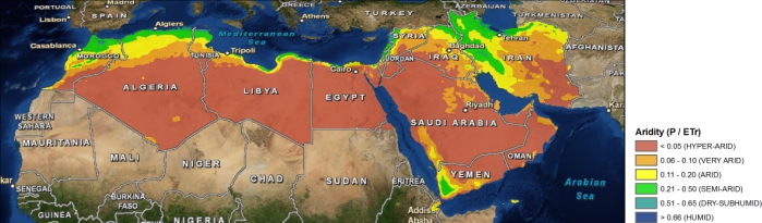
The Middle East and North Africa (MENA) region is considered the most water-scarce region of the world. Disputes over water lead to tension within communities, and unreliable water services are prompting people to migrate in search of better opportunities. Water investments absorb large amounts of public funds, which could often be used more efficiently elsewhere. As the region’s population continues to grow, per capita water availability is set to fall by 50 percent by 2050, and, if climate change affects weather and precipitation patterns as predicted, the MENA region may see more frequent and severe droughts and floods
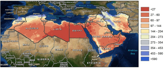
The need for alternative and improved water management options is therefore urgently needed, but a clear overview on what the main focus should be is lacking. A broad range of options exists which can be grouped by different approaches such as reducing the demand, increasing the supply, transfer between different sectors, transfer within different sectors, increase storage etc. An important aspect for the MENA region includes desalination.
To explore different options the World Bank initiated an initiative to generate an improved understanding of water issues in the region and overview of available options under different scenarios of water supply and demand management with special focus on desalination, taking into account the energy nexus and environmental concerns. As part of this initiative, FutureWater will carry out an assessment of water stress in the MENA region, including associated marginal cost of water supply to meet the water supply need. Conducting consultation workshops and meetings will be organized with relevant parties in the region (governmental, universities, civil society groups).
Water shortage is a growing concern and in response to this many countries are developing national water plans in an attempt to allocate water more effectively. In the Middle-East, where water is extremely scarce these water plans are considered as a means to improved water resources planning, but the plans are often based on limited information and data and are always very much focused on water in rivers and groundwater, rather than considering all the components of the water balance in the broader hydrological context. Weaknesses in these water plans often are:
1. Actual water use from irrigated areas is often assumed to be similar to water supplied.
2. There is an emphasis on increasing the so-called water efficiency rather than aiming at increasing water productivity.
3. Water consumption (=evaporation and transpiration) from natural vegetation or bare soils is not considered.
4. Groundwater recharge is poorly understood and based only on groundwater observation wells.
5. Net groundwater use, and to some extent surface water abstraction estimates are based on estimates of pumping hours and pump capacity rather than on actual abstractions.
6. Analysis is based on average conditions.
7. Water plans can be a reflection of preferred policies rather than based on unbiased analyses.
These issues make the estimated water consumption and the, from this derived, potential water allocations often unrealistic. It is however possible by using advanced remote sensing techniques to tackle most of the issues mentioned here. High resolution rainfall observations, accurate evapotranspiration estimates, and biomass production can be obtained at an unprecedented accuracy using remote sensing. Even changes in deep groundwater using changes in gravity fields can be monitored from remote sensing nowadays. Especially the high spatial coverage makes these remote sensing observations a unique product to support the national water plans.
Results based on completed studies in Tunisia, Egypt and Saudi-Arabia using advanced remote sensing techniques, are compared to information used in the national water plans of the three countries. This study assess to what extent these remote sensing observations can support the development of national water plans, improve the understanding of resource availability, better assess where water is consumed, and identify where losses are avoidable.
