Deforestation, population growth, and climate change are only some of the challenges to sustainable landscape management in Madagascar. Severe impacts of land degradation on crop production, water availability and biodiversity are already observed and expected to exacerbate in the future. To address these challenges, the World Bank is supporting the PADAP project, which is based on an integrated approach to landscape management that aims both at promoting economic value, while preserving the critical ecosystem services necessary for sustaining those activities. LAUREL, as a technical assistance to the PADAP program, aims to provide new spatial data and tools to assess the baseline situation regarding land degradation and simulate a range of scenarios on future land use changes and their impacts.
In Madagascar, between 2001 and 2012, on average about four-fifths of the population lived in extreme poverty, which is closely linked to natural resources. The agricultural sector (including agriculture, livestock, forestry, and fisheries) accounts consistently for 25-30 percent of GDP and plays a vital role as a source of jobs, generating more than 70 percent of all employment. Yet, the sector has performed poorly in recent decades. Growth in agricultural value added has lagged behind population increases. Future demographic growth in Madagascar will be accompanied by strong growth in the demand for food, which in turn will increase pressure on the natural resource base. This is a cause for concern; without significant increases in agricultural productivity, food security outcomes are unlikely to improve, and they could well deteriorate.
Deforestation and other forms of natural resource degradation is recognized as a widespread problem which threatens development outcomes. In areas where land is becoming increasingly degraded, crop yields are likely to stagnate or even decline, leading to additional pressure to expand production into marginal areas. As productivity in these areas begins to decline as well, further expansion will be necessary, setting off a vicious circle. Climate change is likely to further compound the challenge of managing landscapes and sustaining their ability to deliver development benefits. The worsening climatic conditions projected in the coming decades are likely to have potentially significant adverse impacts on crop yields and food security.
The $108 Million PADAP project is led by the Government of Madagascar through its Ministries in charge of Agriculture, Environment and Water, and is supported by the World Bank, the Agence Française de Développement and the Global Environment Facility. It is based on an integrated approach to landscape management that aims both at promoting economic value chains (agriculture, forestry, livestock, ecotourism) while preserving the critical ecosystem services, necessary for sustaining those activities. This integrated approach relies heavily on a good choice and planning of land uses on the different land units of the landscape transect.
The assignment Land Use Planning for Enhanced Resilience of Landscapes (LAUREL) is executed by a consortium of WUR, ISRIC, FutureWater, RIKS and WWF Madagascar, and will serve as a companion (and precursor) technical assistance activity in support of PADAP, in particular through the development of a prototype dynamic information framework. The premise of the program is the observation that improved tools for land use planning can make a critical contribution towards identifying effective interventions (e.g. policy reforms, investment programs) and where they should be implemented to ensure that landscapes continue to deliver development benefits in a lasting manner

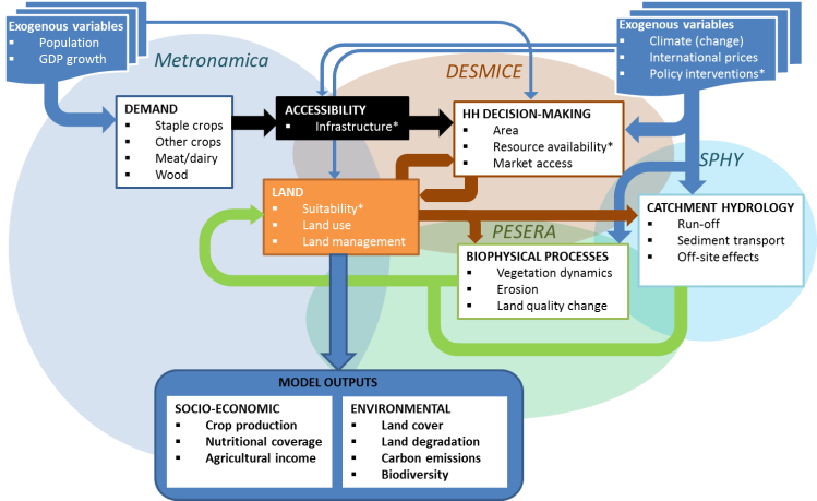
The result of this consultancy assignment is a prototype land use change simulation platform (LANDSIM-P) to be used by the Government to characterize how land use is likely to evolve and assess the consequences of alternative on the achievement of development objectives and environmental objectives. Key output variables include for example land use types and changes, forested area, carbon storage, river discharge, soil erosion rate, crop production and associated nutritional coverage and agricultural income. In particular, FutureWater develops the platform component that relates to simulation of hydrological processes and erosion.
Publicaciones relacionadas
2020 - FutureWater Report 209
Evaluation of PAGDP plans in Madagascar with the LANDSIM-R prototype
Koster, R., G.W.H. Simons


